 Af Kurt Menke
This blog will explain the use of the SLYR – The Esri to QGIS Compatibility Suite – plugin. If you work in a hybrid environment using both QGIS and Esri software, or if you are interested in migrating from Esri to QGIS, SLYR is surely one of the most useful QGIS plugins.
Developed by North Road , this plugin allows you to import all types of Esri project and symbology files into QGIS. This includes ArcMap (*.mxd/*.mxt), ArcScene (*.sxd) and ArcGIS Pro (*.aprx) documents. This can be done via the Browser Panel or via a suite of algorithms found in the Processing Toolbox. As an example, in the animated gif below, an ArcGIS Pro aprx file is opened by QGIS via the Browser Panel. It is as easy as opening a QGIS project from the Browser panel. The project is opened exactly as it looked in ArcGIS Pro with all layer symbology intact It can then be saved as a QGIS project. ArcMap *.mxd documents can be opened in QGIS just as easily.

Support for importing ArcGIS Pro and ArcMap documents includes vector, raster, TIN, point cloud and annotation layers with a very accurate match to the original ArcMap/ArcGIS Pro layer styling. It also maintains layer joins/relations, print layout settings and ArcMap document metadata. Data driven pages are converted to QGIS Atlases.
It is even possible to drag and drop individual layers from ArcMap or ArcGIS Pro documents into QGIS, again respecting all the layer styling settings.
Processing Tools
There are over 30 SLYR processing algorithms in the Processing Toolbox. These are divided into the following categories. Annotations, ArcGIS Pro, AVL Styles, Data conversion, Hyperlinks, LYR datasets, MXD documents, PMF published maps, SDE documents, SLD, Style databases and SXD documents.

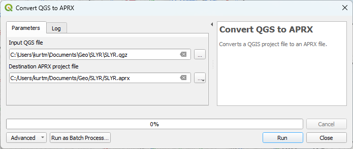
One of these (Convert QGS to APRX), allows you to convert a QGIS map document to an ArcGIS Pro document. This is very new functionality, and there are still some limitations. It can only handle layers using simple QGIS symbology. But for basic QGIS projects it works well.
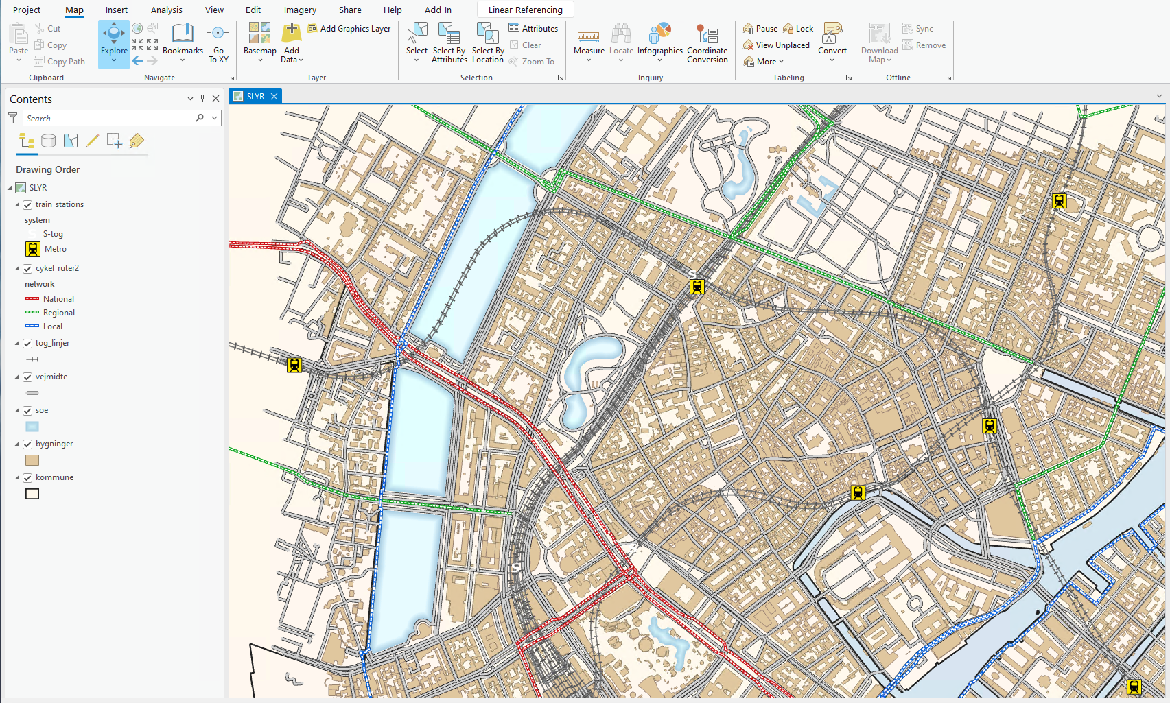
The resulting project is shown below, open in ArcGIS Pro. All layer symbology is maintained.
As with other Processing tools, SLYR algorithms can be run in Batch mode or incorporated into Graphical models to batch convert many Esri project files in a single operation.
Data Conversion
There are SLYR processing algorithms for converting data and Esri style files.
*.lyr files can be added to QGIS via the Browser Panel by dragging and dropping. There are other processing algorithms for converting Esri *.lyr/*.lyrx to either *.sld for use with GeoServer/MapServer or to native QGIS *.qlr files.
Similarly, one can convert entire Esri *.style/*.stylx databases to QGIS style databases. SLYR supports conversion of *.style marker, line, and fill symbols, color palettes, color ramps, text format, label settings and area and line patches. Recently a new tool was developed which allows you to convert QGIS style databases to Esri *.stylx.
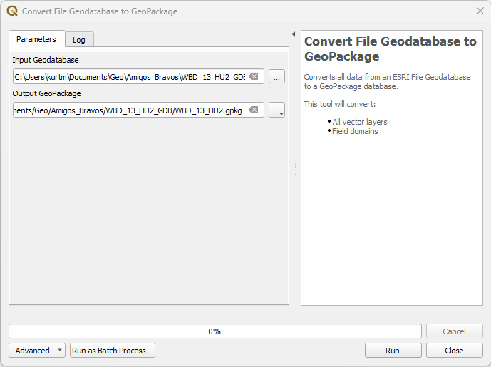
There is also a new algorithm for converting Esri File Geodatabases to GeoPackages. This was just released in May 2023. It includes the conversion of rasters, field domains, and other advanced Geodatabase functionality to their GeoPackage equivalents (Note: this was made possible via new features in GDAL, so this algorithm requires QGIS version 3.28.7). This is incredibly valuable when you work in QGIS but are provided data in an Esri File Geodatabase which includes those advanced features. Previously those had to be manually rebuilt in the QGIS environment.
Licensing
There are two versions of SLYR: A Community Edition and a proprietary closed sourced version. The developer is a passionate open-source proponent and core QGIS developer. However, building these tools requires he spend considerable time reverse engineering Esri file formats. Much of this development has been gratis and therefore the developer has identified a funding goal for each feature. Six months after the pledged funding goal has been reached, that feature lands in the Community Edition. To get all the tools one must purchase a one-time license. Eventually all the features will be available in the Community Edition. The details can be found here: north-road.com/slyr/.
Until recently the Community Edition supported only the conversion of Esri *.style databases. However, the conversion of *.lyr files to their QGIS equivalents recently met the funding goal and is also now available in the Community Edition. To date, conversion of *.mxd documents to QGIS has reached 30% of it’s funding goal.
The proprietary version offers nearly complete conversion of maps and data between Esri and QGIS environments. Conversions from Esri to QGIS are nearly 100% accurate. Conversions from QGIS to Esri is still quite new. It will take more development to convert more complicated QGIS symbology. Plus, new features are continually added: north-road.com/2023/05/31/slyr-update-june-2023/.
If you work with both QGIS and Esri, I encourage you to download the Community Edition and give it a test drive! It is available in the standard QGIS plugins repository and can be found by searching the QGIS Plugin Manager.
If you are interested in learning more about QGIS, we offer a large array of courses. Our fall course calendar has been published and you can read more about our offerings here.